The details below are from the Green Belt Topic Paper by Epsom and Ewell Borough Council. Parts of the assessment are debateable or incorrect, but the details have been produced, after some corrections to spelling.
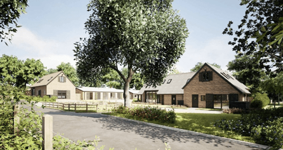
There is a planning application in the pipeline for the Drift Bridge Farm, Reigate Road, Epsom for a much smaller development ( Demolition of all existing buildings and development of 8 dwellings with associated car parking and landscaping ). The details conflict with the information supplied by EEBC for the evaluation of green belt sites.
Drift Bridge Farm, Epsom – Chartwell Land & New Homes
Accessibility
Reg 18 Transport Assessment
The scores 10.5 against the multi-criteria analysis (highest score 25.5). This is low scoring relative to all other PDL/GB sites ranking 251/256. n the context of Green Belt sites the site scores poorly.
Nearest Train Station: Epsom Downs, 0.5 miles (12 mins)
Nearest Bus stops and routes: On Reigate Road past the bridge, south 166 (Epsom to Croydon). Mon-Fri Hourly service
Previously Developed Land or greenfield land (Building 0.31 %; Undeveloped land 96.62 %; Road/Path/track 3.05%)
Assessed Yield: Proposed for a variety of potential uses including 500 residential, specialist housing, leisure, recreation
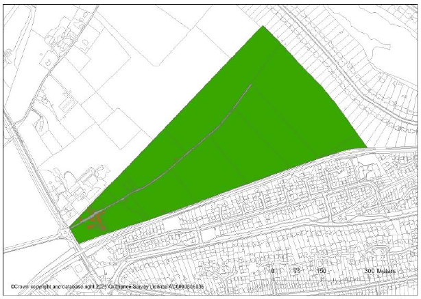
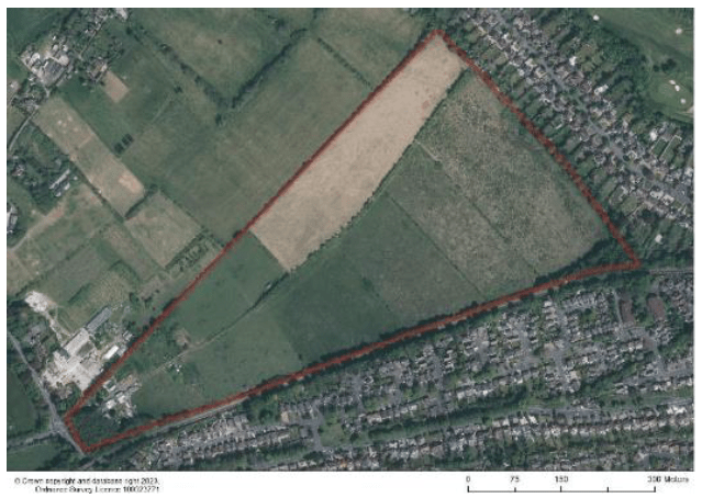
Site Area: 24.02 ha
Site description
The site is a large triangular shaped parcel located at the south-eastern edge of the Borough boundary. It is currently in agricultural use, with a collection of agricultural buildings and a dwelling grouped near the entrance of the site to the west and the rest of the site (over 96%) is undeveloped comprising of varying sized fields, rising to the south.
Access to the site is restricted to the west from Reigate Road (the A240), which is where the site tapers to the narrowest point, widening to the rear (east) which stretches 1.42km from the entrance. The site is heavily vegetated bounded by railway line to the south residential to the east, tree/ hedgeline to the north and Reigate Road to the West.
The site promoter has submitted supporting information suggesting a variety of opportunities for the site including residential, commercial and leisure. No initial or concept masterplan has been submitted.
What is the nature and extent of the harm to the Green Belt in this location if the site is developed? (Calverton (iv))
The site comprises of Green Belt parcel 38 which scores high against purposes of the Green Belt in terms of sprawl and safeguarding the countryside from encroachment, and moderately against the purpose of merging. The overall score for the site is high (8).
In terms of sprawl, when the site is considered in isolation and in the context of the existing Green Belt boundary the site would be an extension of the built form beyond the existing settlement edge south (over the Borough boundary). The southern boundary of the site, also the Borough boundary, is delineated by a railway line which is a strong durable boundary between the GB and non-green belt. The development of the site would result in the loss of this strong defensible boundary of the railway line with a less durable boundary field hedge line along the northern boundary of the site. It is therefore considered significantly harmful in this regard.
In terms of merging, the site scores moderate for this purpose, the gap between the built up edge of Epsom north and the nearest largest settlement is Nork (Banstead) to the South, between the two railway lines is approx. 2km. The development of the site would reduce the gap by approximately 300m (measured midway from the site). Therefore the development of the site would cause a degree of harm but a healthy buffer could still be maintained. However It should also be noted that there is a scattering of development peppered in the area to the east of Reigate Road including industrial uses and a gated ribbon development, therefore in this context, a degree of occurred here although is washed over by the Green Belt.
In terms of assisting in the safeguarding of encroachment of the countryside, the site is predominanty (over 96%) undeveloped but a small area to the west is previously developed. The site is also in the vicinity of urban development to the east and south – although the influence of the southern residential area is limited, where the railway line creates a distinctive physical and visual edge. The character of the area feels like a transitional landscape moving away from the urbanized core to the north to a quieter area moving south and then opening up again to a more urbanized environment past the railway bridge. Therefore there would be a degree of harm but it’s proximity to urbanising features is recognised.
Defensible Boundaries: The site itself is self-contained defined by clear physical features including field boundary, property boundaries and railway line to the south. The southern boundary, also the Borough boundary, is delineated by a railway line which is a strong durable boundary between the GB and non-green belt. The development of the site would weaken this edge making the area vulnerable to future development. Increasing the chances of creep from the south. It is therefore considered significantly harmful in this regard.
To what extent can the consequent impacts on the purposes of the Green Belt be ameliorated or reduced to the lowest reasonably practicable extent? (Calverton (v))
Sprawl: The development of the site would represent sprawl from the South, penetrating the railway line the currently forms a strong boundary line. The level of harm is considered
significant and could not be satisfactorily ameliorated.
Merging: The development of the site would reduce the 2km gap between Epsom and Nork however a sufficient gap would still remain. There is already development scattered in this area and therefore urbanising features already exist, however spread out which minimises the impact they have. The penetration of the railway line boundary to the south removes a strong boundary edge and could set a precedence for the gradual ebbing away of the gap here.
Safeguarding encroachment of the Countryside: The site promoters have not provided any supporting information to identify the development of the site. The site would have to be carefully master-planned, to reduce harm to the surrounding character to ensure any built form preserves respects the edge of settlement character. A landscape and visual impact assessment LVIA could be carried out alongside any proposal for the site. However, it is considered that the level of harm could not be satisfactorily ameliorated in light of the impact of the other purposes.
Defensible Boundaries: The development of the site would result in the weakening of a strong Green Belt boundary which also forms part of the Borough boundary. The railway line and bridge adjacent to the site creates a clear, distinctive clean edge which have distinctly different characters.
Conclusion
To whether there are exceptional circumstances to justify the release of the site from the Green Belt.
- The site comprises of Green Belt parcel 38 which scores high against purposes of the Green Belt in terms of sprawl and safeguarding the countryside from encroachment, and moderately against the purpose of merging. The overall score for the site is high (8).
- The main impact from the development of the extension of the Green Belt from Nork and the breach of a strong durable boundary of the railway line to the south which also forms the Borough Boundary. The site would also reduce the gap between these areas.
The level of harm is recognised on this high scoring site and concluded that the development of the site would result in sprawl from the south and breach an existing strong durable boundary making the area vulnerable to further development in the future. Based on the above it is considered that exceptional circumstances do not exist justifying an amendment
to the Green Belt boundary here.

One response to “Development at Drift Bridge Farm – NON021”
it’s already so busy around there with traffic it’s going to make it impossible by adding more houses. Why can’t we keep the land as it is?
LikeLike