
The details below are from the Green Belt Topic Paper by Epsom and Ewell Borough Council. The two sites are Downs Farm . The Northern parcel is in Ewell. The Southern parcel is in Epsom, bordering with Nork.
Several parts of the assessment are debateable or incorrect, but the details have been produced “as is”, after some corrections to spelling. There are two sites, but they are being treated as one site, which is debatable. The two sites are large, so one public transport assessment is very questionable. The train services and the bus service are poor. the scoring of the two sites is identical, but the circumstances are different.
Accessibility – Reg 18 Transport Assessment
The site scores 12.5 against the multi-criteria analysis. This is low scoring relative to other PDL and Green Belt sites assessed (highest score 25.5), ranking 235/256.
Well served by public transport?
Nearest Train Station: Epsom Downs 0.8 miles 17 min walk. Ewell East station, 1.2 miles, 25 min
Nearest Bus stops and routes: Along Reigate Road past the railway bridge south 166 (Epsom to Croydon). Mon-Fri Hourly service
Previously Developed Land or greenfield land
Building 0.35 %; Undeveloped land 96.75 %; Road/Path/track/rail 1.59%, general surface 1.29%
Site Area: 27.97ha NON016 (north), 17.92ha NON042 (south)
Assessed Yield:
Northern parcel 675 residential units, park, school and employment, GI on southern parcel
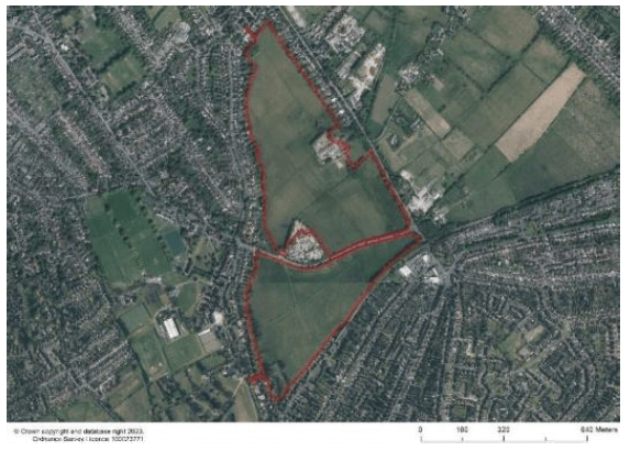
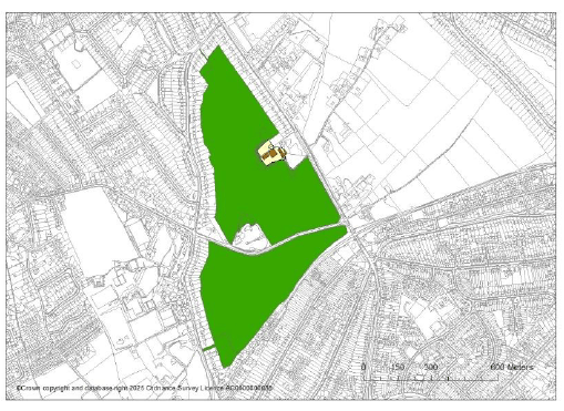
Site description
The site comprises two large triangular parcels intersected by College Road. The site promoters are only proposing development on the northern parcel and Green Infrastructure including pedestrian footpaths to the southern parcel. The existing uses include paddocks, pasture, farmland with some light Industrial use and small business units within a small collection of buildings on the northern parcel. The southern parcel consists of undeveloped land.
The northern parcel of the site is wrapped/contained by existing residential development ribbon development on to the NE and West. Exiting access onto the northern parcel is midway down the parcel along Reigate Road where there is an existing access road to the industrial uses there. There are some light industrial/skip hire uses located on the southern part of the northern parcel which gain access from College Road. The southern parcel is bounded by ribbon development to the west and partly south, as well as the railway line to the south, and the northern boundary is College Road which leads to a pinch point to the east. The northern parcel possesses north facing slopes, views are possible across the site. Thick vegetation along the edges help to screen views of the elevated site from the surrounding roads.
As you move south, away from the more urbanized centre, Reigate Road changes into a more rural/edge of settlement character, The pedestrian pavement on the western side of the road disappears, and there is only a single pedestrian pavement along the length of College Road that intersect the parcels. The site forms part of the gap of 1.14km between the Epsom and residential areas of Nork, adjacent to the Epsom Downs Station.
The site promoters (Regulation 19 REP098 Dandara) have submitted supporting information including an analysis of the site and a conceptual masterplan which recommends a public open space to the southern part of the northern parcel to retain a gap between Epsom and Nork. They are also proposing the retention of the southern parcel in the GB to retain a visual and physical separation with enhanced ‘green links’ providing pedestrian and cycling movement in the area.
What is the nature and extent of the harm to the Green Belt in this location if the site is developed? (Calverton (iv))
The site comprises of two parcels north and south which correspond to two separate GB parcels. The scores are the same for each purpose for both parcels, both scoring an overall moderate score of 6. The sites score high against purposes of the GB in terms of merging, moderately against the purpose of safeguarding the countryside from encroachment and low for the purpose sprawl. In terms of sprawl, when the site is considered in isolation and in the context of the existing Green Belt boundary the site would be an extension of the built form beyond the defined Urban Area south, however the site is surrounded by built up development, particularly to the west and ribbon development is present on the western side of both parcels – therefore in this context, development of the built up area has already occurred here, however to the east and south these areas are currently washed over by the Green Belt. Therefore the site itself has minimal impact on this purpose.
In terms of merging, the site scores high for this purpose, the nearest largest settlement is Nork to the South where this site creates an approximately 1.14km gap. The development of the site would reduce the gap between these areas. Therefore the development of the site would cause some harm here. However as noted above, there has been a degree of development that has already occurred between these neighbouring areas in the form of ribbon development – so technically the harm in terms of merging has occurred.
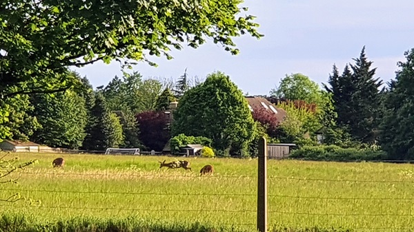
The site promoters are proposing the northern parcel be developed and retaining the southern parcel for GI. In terms of assisting in the safeguarding of encroachment of the countryside, the site is predominantly (over 96%) undeveloped but parts of the site are previously developed. The site is also surrounded by urban development, some visible. The character of the area feels like a transitional landscape moving away from the urbanized core, pedestrian pavements begin to fade and becomes quieter and more open. Therefore, there would be a degree of harm but it is recognised that the area consists for urbanising elements.
Defensible Boundaries: The site itself is self-contained, hemmed in by residential ribbon development, vegetated boundary, roads and railway lines. North – clear defensible boundaries – residential development on most sides and south of the parcel bounded by College Road and the Chalk Pit employment site South – clear boundaries – part rail line and station and residential to south, residential to west and College Road to North.
To what extent can the consequent impacts on the purposes of the Green Belt be ameliorated or reduced to the lowest reasonably practicable extent?
(Calverton (v))
Sprawl: As noted above, the site has minimal impact on this purpose where built development has already extended the boundary here, albeit currently washed over. The site promoters have considered the context of their site and are proposing development occurs on the northern parcel and GI on the southern parcel. An initial concept masterplan has been submitted indicating that a green buffer would round off the built form to the south of the northern parcel. This would reduce the extent of potential harm here in regard to sprawl.
Merging: The development of the site would reduce the gap between Epsom and Nork, however the site promoters are proposing development be confined to the northern parcel leaving the southern parcel for Green Infrastructure. Therefore, the extent of harm is reduced. A gap of approximately 300m between the indicative building line of the northern parcel and end of the southern parcel would be retained, minimising the extent of the harm. Whilst this is a significant reduction in the existing extent of the gap, it is noted above that existing ribbon development has already occurred and started to merge this area. The topography of the site could be used, and the use of natural screening could be reinforced to aid the sense of separation of areas.
Safeguarding encroachment of the Countryside: The site promoters are proposing the southen part of the site remain open, assisting in reducing encroachment to the more open countryside moving south where it becomes more quieter and more open. To reduce harm to the surrounding character, any future development should be carefully masterplanned to ensure any built form preserves respects the edge of settlement character. A landscape and visual impact assessment LVIA should be carried out alongside any proposal for the site.
Defensible Boundaries: The site has well defined boundaries on all sides which is considered capable of forming a new Green Belt boundary. An initial concept plan of the site shows the southern part of the northern parcel being retained for green infrastructure. This would reinforce the green buffer to the southern parcel.
The southern parcel is proposed for enhanced Green Infrastructure and new paths, which would not require changes to the Green Belt boundary.
Conclusion as to whether there are exceptional circumstances to justify the release of the site from the Green Belt.
- The site comprises of two parcels north and south which correspond to two separate GB parcels. The scores are the same for each purpose for both parcels, both scoring an overall moderate score of 6. The sites score high against purposes of the GB in terms of merging, moderately against the purpose of safeguarding the countryside from encroachment and low for the purpose sprawl.
- The proposal for the redevelopment of PDL part of the site would not be inappropriate development and would not require exceptional circumstances to be demonstrated.
- The main impact from the comprehensive redevelopment of this site would be the merging of Epsom and Nork (over the Borough Boundary) and the reduction of the gap between these areas. However, it is noted above that ribbon development has occurred here effectively reducing this gap already, although it is washed over by the Green
Belt. The site promoters are proposing that development of the northern part of the northern parcel, and GI on the southern parcel, therefore maintaining a degree of separation between Epsom and Nork.
Whilst some degree of harm is recognised, it is concluded that the impact from development that is focussed on the northern part of the northern parcel could be ameliorated. The green buffer from the northern parcel and the southern parcel retained for Green Infrastructure would ensure a degree of separation is maintained between the urban area of Epsom and Nork.
Based on the Calverton test above it is considered that there are exceptional circumstances justifying an amendment to the Green Belt boundary for the northern parcel of the site.

One response to “Development at Downs Farm – NON016,NON042”
Downs farm was not part of the local plan approved in 2024/25 clearly from this blog greed is taking over common sense, it’s a nonsense why anyone would build houses let alone a school either adjacent or opposite a major recycling centre beggars belief and does the councillors who supposedly are lobbying the planners no credit whatsoever.
Mr and Mrs M C Bond KT174JP
LikeLike