The details below are from the Green Belt Topic Paper, published recently by Epsom and Ewell Borough Council. The scope of the different is different to that to be presented by the developer at the public engagement event in Bourne Hall in Ewell on 24th February 2026, 3:30 to 7:00pm.
Several parts of the assessment are debateable or incorrect, but the details have been produced “as is”, for information. It is uncertain if the details are approved or endorsed by Epsom & Ewell Council.
The train services are poor. Cheam Road is already very busy and slow during peak hours, which will affect bus services and journeys by car.
Previously Developed Land or greenfield land
Undeveloped land 78.60 %; Road/Path/track 5.63%; General Surface 15.75%
Assessed Yield: 250-350 residential units
Site Area: 8.63 ha
Accessibility – Reg 18 Transport Assessment
The scores 16 against the multi-criteria analysis (for context the highest score was 25.5). This is moderate scoring relative to all other Previously Developed Land/Green Belt sites assessed, ranking 203/256 In the context of other GB sites, the site ranks moderately in this regard
Well served by public transport?
Nearest Train Station: Ewell East (north west of the site along public right of way)
Nearest Bus stops and routes: Multiple stops along Cheam Road, S2 Regular service every 15-20 mins Epsom to St Helier Station
Site description
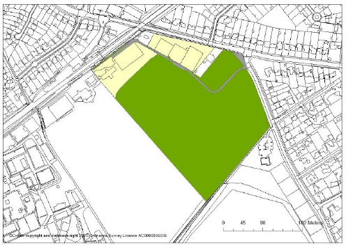
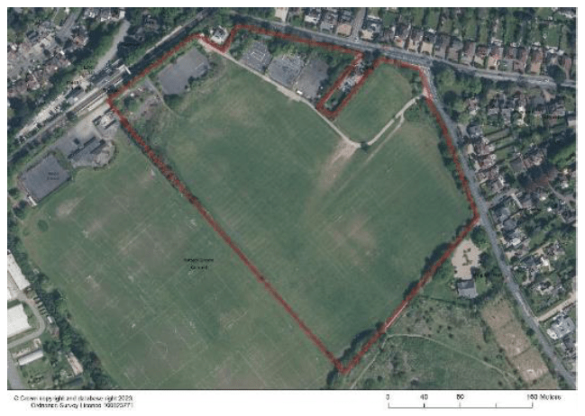
The site consists of open space/playing fields, (approximately 78%) and previously developed land to the north-comprising of hard surfacing and former tennis courts. The proposal for the redevelopment of PDL part of the site would not be inappropriate development and would not require exceptional circumstances to be demonstrated. The site borders the railway line, Cheam Road (the A232) and Banstead Road, with public rights of way to the north (parallel to the railway line) west (along the edge of Nescot College) and south of the site where Priest Hill Nature Reserve is located. The Nature Reserve is also a Site of Nature Conservation Importance (SNCI).
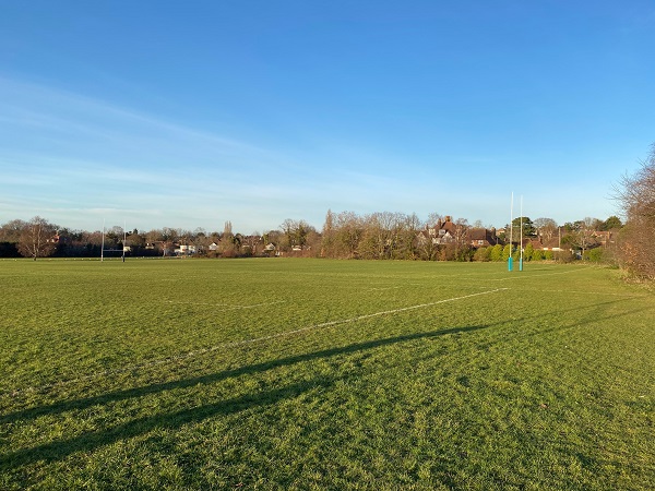
The site is not publicly accessible, and the southern part of the site is used by a community Rugby club and provides 3 senior pitches and 1 mini pitch. The remaining part of the site was previously used by another Rugby club however their use of the site for sport ceased in 1999. The development of the site would result in the loss of outdoor sports pitches which would need to be justified and replace/re provided on site or elsewhere.
The site is located adjacent to busy roads (Cheam Road and Banstead Road) and Ewell East railway station. The site is surrounded by residential development along three of its five edges and is influenced by the adjoining urban character. The site forms the settlement edge of Ewell East. The boundary of the site consists of vegetation, the varying degrees of density, allowing for glimpses into the site.
The site promoters (REG19 REP163 Carter Jonas ono Coldunell) have submitted supporting information and an illustrative masterplan and most recently pre-application report/document as part of their regulation 19 response. The latter promotes the site in two phases comprising the development of the site into 283 dwellings to the northern half, with the second phase developed into 161 dwellings and a central green park/square and linear park along/green buffer on the southern boundary.
What is the nature and extent of the harm to the Green Belt in this location if the site is developed? (Calverton (iv))
The site forms part of (46%) of a larger GB parcel 43, which scores high against purposes of the GB in terms of sprawl and merging and scores moderately against the purpose safeguarding the countryside from encroachment. The overall score is high (8) In terms of sprawl, when the site is considered in isolation, the potential harm is that the development of this site would be extension of the built form beyond the existing settlement edge to the north, NW and NE. However, the site is part PDL to the north (15-20%) with the remaining part of the site being open sports field. Therefore, the extent of harm is recognised but the site is partly pdl and adjacent to urban development which it is already influenced by.
In terms of merging, although the wider parcel within which the site is located scores high for this and the site does make up a gap between Ewell and Banstead. The gap between the built up edge of Ewell north and Banstead (Banstead) to the South is appproximately 2km. The development of the site would reduce the gap by approximately 380m, the development of the site would cause a degree of harm but on balance a healthy buffer could still be maintained. In addition, the site adjoins Priest Hill Nature Reserve to the south, a Site of Nature Conservation Importance (SNCI) which contributes ignificantly to the buffer and will ensure it remains.
In terms of assisting in the safeguarding of encroachment of the countryside, the site is PDL to the north with the remaining area an open sports field, whilst it would result in result in encroachment into the countryside. The urban influence of the site’s proximity and relationship with the adjoining environment / character along Cheam Road is strong, as you move south along Banstead Road it becomes quieter and has a more edge of settlement, countryside character. Therefore, there is limited harm except perhaps to the southern part if the site.
Defensible Boundaries: The site has clear defensible boundaries, public right of way to the SW, railway line to the NW, public highway the north and east. However, the site in isolation is an awkward shape that protrudes south and may make the adjacent parcel to the west (Nescot College) which forms part of the Green Belt Parcel 43 vulnerable to development in the future.
Concluding Assessment of whether there are exceptional circumstances to release of the site from the Green Belt.
- The site forms part of (46%) of a larger Green Belt parcel 43, which scores high against purposes of the Green Belt in terms of sprawl and merging and scores moderately against the purpose safeguarding the countryside from encroachment. The overall score is high (8).
- In isolation, the main impact from the development of the site is sprawl and to a lesser degree merging and safeguarding the countryside from encroachment. Development of the site could be concentrated to the northern part of the site where the previously developed land is located and carefully master-planned with gradients of development, more intensive to the north/centre of and lower density on the edges. the height, mass and density of development could be carefully considered to reduce harm to the surrounding character to ensure any built form preserves respects the edge of settlement character moving south.
- A landscape and visual impact assessment LVIA should be carried out alongside any proposal for the site.
Whilst it is recognised that the parcel is overall high scoring against the Green Belt purposes, the site is on the edge of settlement with a close relationship with the adjoining urban character, whilst there is a degree of harm, it is concluded that harm from the comprehensive development of the site could be ameliorated for the site. Therefore, on balance, based on the Calverton test it is considered there are exceptional circumstances justifying an amendment to the Green Belt boundary.
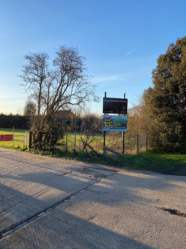
Entrance to Priest Hill Playing Fields, Banstead Road, Ewell

2 responses to “Development at Priest Hill, Ewell – NON013”
This is such an important and well researched breakdown of the NON013 site assessment. The point about the site’s awkward shape and how it protrudes south potentially making Nescot College vulnerable to future development is a detail that many peole would miss but is genuinely worrying. The transport concerns around Cheam Road are very real too, and it’s good to see them raised clearly. Thank you for keeping the community informed with this level of rigor.
LikeLike
these houses will be expensive because of the good local transport.our children will not be able to buy and this will bring in outsiders .i agree we need housing but at a cost .how many will be social housing none if you have your way .social housing is what we need desperately in the borough.
LikeLike